The author of this blog is no longer active in education having retired from Caterham high School. Therefore, no new posts will appear after this. However, the previous posts will remain as an archive.
Thank you for taking the interest to look at the posts on this blog.
Geography rocks!
Friday 15 March 2019
Tuesday 9 September 2014
Congratuations .....again
Caterham geographers have scored yet another success. The GCSE results for 2014 are in and show a remarkable consistency, given the changes to the exams this year. There were twenty-five candidates more than in 2013 and this has helped add to the excellent result. This was......85% achieving grades between A* and C which is 20% above the national rate for OCR B. 40% achieved an A* or A grade which compares with 24% national rate. There was a 100% pass rate. Well done everyone - we're very proud of you!
Wednesday 4 September 2013
Managing the Afon Conwy
The title for the 2014 Field-work Focus, "How well managed is your chosen stretch of river?" opened possibilities to study the management issues of the Afon Conwy which flows for over 50 km northwards from Migneint Moor into the Irish Sea at Conwy. Draining an area of 590 km2, the river is subject to flooding, especially around the town of Llanrwst. Its headwaters are found on the hard impermeable rocks of Migneint Moor, an are which receives over 2000mm of rain per year. The saturated peat of the moorland cannot absorb much of the water, so its runs off quickly, which in turn leads to flooding. Llanrwst happens to be situated well down the river downstream from where many tributaries like the Lledr and Llugwy join, so contributing their waters to the overall discharge.
In 2004 the river flooded both Llanrwst and its neighbouring village of Trefriw to such an extent that an improved flood strategy was formulated. These management techniques formed the focus for the study.
 | |||||||||||
| Afon Conwy to the north of Llanrwst. |
 |
| A rare sight - the Afon Bach, a dry tributary of the Conwy. |
 | ||
| The Dutch dam - a flexible flood control measure at the junction of Watling Street and Bridge Street. |
 | |||||||||||||
| Dutch dam raised to show operation. (www.dutchdam.com) |
 |
| Outflow of the flood alleviation culvert taking excess flow from the Afon Bach to the Conwy |
 |
| Caterham Geographers at work |
Snowdonia 2013
The annual GCSE field-trip based in Betws-y-coed, in the Beautiful Snowdonia National Park.
Sunday 1 September 2013
Congratulations
Caterham Geographers who sat their GCSE exam this summer have achieved the best ever grades with 86% gaining a grade between A* and C. Also 47% achieved either an A* or A grade. Well done to everyone for their hard work and well deserved success. Hoping to see many of you in the new A Level group.
Wednesday 13 February 2013
Re-branding Rural Devon
 |
| Caterham Geographers at Dartington |
Transition Town Totnes hit the headlines with its battle against corporate takeover when it defeated plans by Costa Coffee to open a branch in the town. The High Street is well known for its independent shops and businesses and locals wanted to keep it that way so they campaigned to keep Costa out. In the end, the company decided to withdraw its plans and get some positive publicity by listening to the people. It remains to be seen if this is the end of the story.


Transition Towns is an international network of communities which "have started up projects in areas of food, transport,
energy, education, housing, waste, arts etc. as small-scale local
responses to the global challenges of climate change, economic hardship
and shrinking supplies of cheap energy." (transition network.org). Totnes is part of this network and a good idea of what this involves can be found at their website, http://www.transitiontowntotnes.org/. All around town there are signs of raising the profile of ideas such as "incredible edibles", planters where herbs and soft fruits can be picked at will by passers-by. This is linked to the idea of community gardens. It would be easy for conservatives to sneer at these attempts as woolly-minded gestures, however that would be foolish given the news being filled with the failures of big business and the gloomy projections of the future after Peak Oil. Knowing the provenance of food is becoming increasingly important for many people, especially when considering the horse-meat fiasco!
 |
| An incredible edibles planter on Steamer Quay, Totnes. |
 | ||
| Converted warehouses on the Dart at Totnes |
 |
| Totnes upper town, home to the concentration of independent businesses. |
Another aspect of rural re-branding is the diversification of farming into other areas. A good example of this was seen at Riverford Organics, suppliers of veg boxes around the country.
 |
| The Riverford Organics farm shop at Staverton, to the north of Totnes. |
An alternative vision is the Dartington Cider Press, which started as a venue for local artists but has since developed into a complex of shops selling tourist goods such as aromatics, food, crystal and ceramics. It is claimed profits go to support the trust's charitable activities. Both fit in with the ethos of keeping wealth within the local area. This is true of transition Towns as well. The Totnes Pound is designed to help participating businesses keep the wealth they generate within the local economy.

The ideas seen certainly give food for thought.
Tuesday 12 February 2013
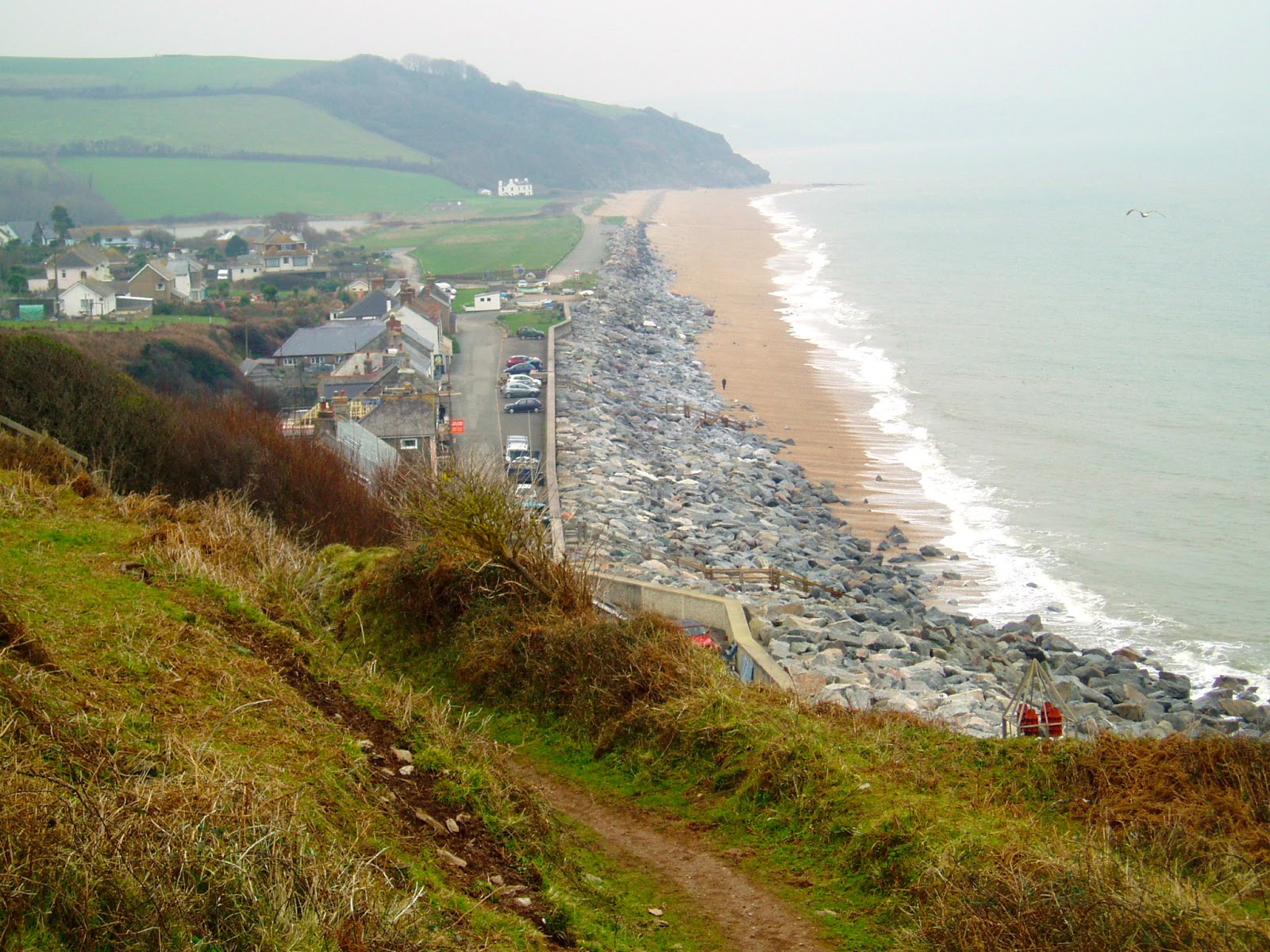
Start Bay Management
 | ||
| Ready for an 8km hike along the coast |
Start Bay has to have one of the most beautiful of England's coastlines. Stretching from Start Point northwards, it has headlands, shingle bars, freshwater lagoons, attractive villages and even the lost village of Hallsands.
This last place was the scene of a Victorian melodrama, where honest fisher-folk were pitted against the power of an industrialist's money, the Royal Navy and the machinations of a secretive and uncaring British government. Needless to say, the villagers lost, their village was destroyed by the sea, their compensation meagre and justice denied by the government's suppression of a report that recommended a far more generous settlement. The story is told very well by new interpretation boards on the viewing platform overlooking the ruins. The full story can be seen at the excellent website, .http://www.abandonedcommunities.co.uk/hallsands6.html.
 |
| The remains of Hallsands village - from the viewing platform. |
On to North Hallsands, where the cottages were built to rehouse some of the displaced inhabitants of the abandoned Hallsands. The beach sediment is exceptionally low and it has exposed layers of peat which are normally covered by shingle. It makes the tragedy of Hallsands even easier to visualise when compared with previous years, as the following two photos show.
 |
| North Hallsands beach 11.02.2009 |
 |
| North Hallsands beach 12.02.2013 |
At the village of Beesands, the picture was the same, the beach being dramatically lower than in previous years.
 |
| Beesands showing the exposed rock armour in front of the sea wall. |
 |
| The rock armour and sea wall 12.02.13 and compare this with the photo below taken in roughly the same place (look for orange rock). |
 |
| Beesands 09.02.11 |
On to Torcross and the dramatic fall in beach level has exposed the foundations of the large sea wall constructed after the storm of January 1979 nearly destroyed the village.
(Video courtesy of Slapton Field Centre)
These photos show the situation.
 | |
| View north 12.02.13 - the sea-wall foundations are exposed. |
 |
| Torcross beach on 11th February 2009 - the shingle is piled up against the wave return wall. |
 |
| Torcross beach 12.02.13 - the same spot as above - note the derrick which is also just visible on the left hand side of the photo above. The beach must be about 3m lower than in 2009. |
 |
| Shingle bastion at the Monument car park. A soft engineering method that replenishes the beach with material ferried down from the northern end at Strete Gate. Longshore drift will carry it northwards again, so keeping the beach material within its sediment cell. |
 |
| Slapton Ley 12.02.13 |
 |
| Paragliders near Start Point. |
Subscribe to:
Posts (Atom)